Storm Surges: Difference between revisions
| (7 intermediate revisions by 2 users not shown) | |||
| Line 1: | Line 1: | ||
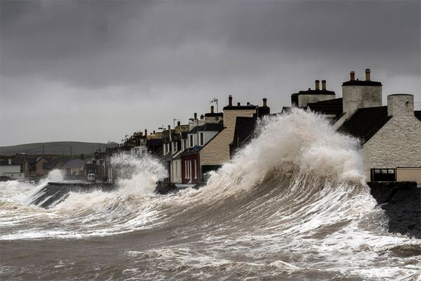
[[File:Storm-surge.jpg|thumb|600px|Storm surge (Source: Surfer Today<ref>Retrieved from https://www.surfertoday.com/environment/what-is-a-storm-surge on October 24, 2024. </ref>)]] | |||
==What is Storm Surge?== | ==What is Storm Surge?== | ||
| Line 30: | Line 32: | ||
|[https://experience.arcgis.com/experience/203f772571cb48b1b8b50fdcc3272e2c View] | |[https://experience.arcgis.com/experience/203f772571cb48b1b8b50fdcc3272e2c View] | ||
|[https://www.nhc.noaa.gov/nationalsurge/ Access] | |[https://www.nhc.noaa.gov/nationalsurge/ Access] | ||
|- | |||
|NOAA 3-D Surge and Tide Operational Forecast System for the Atlantic Basin (STOFS-3D-Atlantic) | |||
|STOFS-3D-Atlantic provides 24-hour nowcasts and up to 96-hour forecasts for water levels, temperature, salinity, and currents in the Atlantic Basin. This system supports marine navigation, weather forecasting, and disaster mitigation, and uses inputs from the National Water Model (NWM) and various NOAA forecast models. It features a high-resolution, unstructured grid to model coastal and inland flooding. Data outputs include formats like NetCDF, GRIB2, and GPKG. | |||
| | |||
|[https://registry.opendata.aws/noaa-nos-stofs3d/ AWS link] | |||
|- | |- | ||
|Global storm surge reconstructions (GSSR) | |Global storm surge reconstructions (GSSR) | ||
| Line 40: | Line 47: | ||
|[https://tidesandcurrents.noaa.gov/inundationdb/ View] | |[https://tidesandcurrents.noaa.gov/inundationdb/ View] | ||
|- | |- | ||
|USGS Coastal Change Hazards Portal | |USGS Coastal Change Hazards Portal<ref>https://www.usgs.gov/tools/coastal-change-hazards-portal</ref> | ||
|This portal provides a comprehensive collection of data related to coastal hazards, including storm surge, from a wide range of historical storms. These data are suitable for use in land use planning projects, storm response and recovery protocols, and infrastructure, ecosystem, and cultural resource management decision-making. Resources are organized under three coastal hazard themes: extreme storms, shoreline change, and sea level rise. | |This portal provides a comprehensive collection of data related to coastal hazards, including storm surge, from a wide range of historical storms. These data are suitable for use in land use planning projects, storm response and recovery protocols, and infrastructure, ecosystem, and cultural resource management decision-making. Resources are organized under three coastal hazard themes: extreme storms, shoreline change, and sea level rise. | ||
|[https://marine.usgs.gov/coastalchangehazardsportal/ View] | |[https://marine.usgs.gov/coastalchangehazardsportal/ View] | ||
| | | | ||
|} | |} | ||
</div> | </div> | ||
== References == | == References == | ||
<references /> | <references /> | ||
Latest revision as of 19:57, 24 October 2024

What is Storm Surge?
Storm surge is the abnormal rise in seawater level during a storm, measured as the height of the water above the normal predicted astronomical tide. The surge is caused primarily by a storm’s winds pushing water onshore. The amplitude of the storm surge at any given location depends on the orientation of the coast line with the storm track; the intensity, size, and speed of the storm; and the local bathymetry.
Storm tide is the total observed seawater level during a storm, resulting from the combination of storm surge and the astronomical tide. Astronomical tides are caused by the gravitational pull of the sun and the moon and have their greatest effects on seawater level during new and full moons—when the sun, the moon, and the Earth are in alignment. As a result, the highest storm tides are often observed during storms that coincide with a new or full moon.[2]
Storm surges are a significant coastal hazard associated with low-pressure weather systems, such as cyclones, hurricanes, and typhoons, which can lead to severe flooding and are a risk for coastal communities. As of February 2015, the dataset comprises over 700 recorded storm surge events.
Datasets
| Dataset | Description | Map viewer link | Data access link |
|---|---|---|---|
| Global Peak Storm Surge Map[3] | The Global Peak Storm Surge Map is a comprehensive resource that documents the location and magnitude of storm surges worldwide since 1880. | View | Access |
| NOAA storm surge data[4] | Storm surge forecast generated by a physics-based model SLOSH. | Access | |
| National storm surge risk maps[5] | An inundation maps for Category 1-5 hurricanes using the SLOSH model. | View | Access |
| NOAA 3-D Surge and Tide Operational Forecast System for the Atlantic Basin (STOFS-3D-Atlantic) | STOFS-3D-Atlantic provides 24-hour nowcasts and up to 96-hour forecasts for water levels, temperature, salinity, and currents in the Atlantic Basin. This system supports marine navigation, weather forecasting, and disaster mitigation, and uses inputs from the National Water Model (NWM) and various NOAA forecast models. It features a high-resolution, unstructured grid to model coastal and inland flooding. Data outputs include formats like NetCDF, GRIB2, and GPKG. | AWS link | |
| Global storm surge reconstructions (GSSR) | A database of daily maximum surge values for the past at 882 tide gauges distributed along the global coastline. The reconstruction is based on a data-driven model, utilizing five different atmospheric reanalysis products with varying spatial and temporal resolutions to generate surge information for the periods covered by each reanalysis[6]. | View | Access |
| NOAA’s Coastal Inundation Dashboard[7] | It provides near real-time water level information, as well as storm track and intensity forecast, active coastal flood and storm surge watches and warnings. Storm surge inundation datasets are created using the high tide scenario SLOSH MOM products for all regions. | View | |
| USGS Coastal Change Hazards Portal[8] | This portal provides a comprehensive collection of data related to coastal hazards, including storm surge, from a wide range of historical storms. These data are suitable for use in land use planning projects, storm response and recovery protocols, and infrastructure, ecosystem, and cultural resource management decision-making. Resources are organized under three coastal hazard themes: extreme storms, shoreline change, and sea level rise. | View |
References
- ↑ Retrieved from https://www.surfertoday.com/environment/what-is-a-storm-surge on October 24, 2024.
- ↑ https://oceanservice.noaa.gov/facts/stormsurge-stormtide.html#:~:text=Storm%20surge%20is%20the%20abnormal,storm's%20winds%20pushing%20water%20onshore.
- ↑ https://surge.climate.lsu.edu/data.html
- ↑ https://vlab.noaa.gov/web/mdl/storm-surge
- ↑ https://www.nhc.noaa.gov/nationalsurge/
- ↑ Tadesse, M.G., Wahl, T. A database of global storm surge reconstructions. Sci Data 8, 125 (2021). https://doi.org/10.1038/s41597-021-00906-x
- ↑ https://oceanservice.noaa.gov/facts/storm-dashboard.html
- ↑ https://www.usgs.gov/tools/coastal-change-hazards-portal