CRL Map: Difference between revisions
mNo edit summary |
→Methodology: refactor 1 |
||
| Line 199: | Line 199: | ||
= Methodology = | = Methodology = | ||
This section | This section outlines the methodology behind the Climate Risk Mapping Platform, divided into three key categories: Physical Assets, Climate Science, and Risk Metrics. | ||
== | == Physical Assets == | ||
Physical asset data forms a critical component of climate risk assessment. These assets—such as structures, facilities, and infrastructure—represent the elements that, if affected by climate events, could have significant impacts on communities and economies. Our objective is to develop a standardized physical asset data model that can be represented within a database. This model will contain a comprehensive set of asset properties, enabling downstream integration with climate data for the calculation of asset-specific risk metrics. | |||
Currently, we source this data from OpenStreetMap (OSM). The raw data undergoes processing to extract the relevant infrastructure types and prepare them for use in the climate risk model. We cross-reference* the infrastructure data with other external sources to ensure both accuracy and completeness, ultimately creating a reliable dataset for physical asset analysis. | |||
[https://github.com/UW-Climate-Risk-Lab/climate-risk-map/tree/main/backend/physical_asset Github: Physical Asset] | |||
<nowiki>*</nowiki>''Infrastructure Validation Pipeline Coming Soon'' | |||
== Climate Science == | |||
One major challenge in assessing climate-related financial risk is the disparity between the granularity of climate hazard data and exposure data. Current CMIP6 climate models often provide climate projections at resolutions of 100 km or coarser, whereas exposure data, such as power infrastructure data from OpenStreetMap has a resolution of 250 meters and finer. To have a meaningful risk assessment, climate hazard data must be downscaled to match the resolution of exposure data. | |||
== | == Risk Metrics == | ||
= Data Dictionary = | = Data Dictionary = | ||
Revision as of 18:12, 15 October 2024
Welcome to the Climate Risk Map!
This guide is designed to walk you through the Climate Risk Map platform, helping you understand the project and how to get started with the tool. Whether you're new to climate risk or an experienced analyst, this guide will walk you through the key features of the platform, including a comprehensive overview of its capabilities, a step-by-step user quick-start guide, detailed methodology behind the data processing, and insights into the data sources powering the platform.
Overview
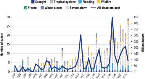
“40 years ago, the US experienced a billion-dollar disaster every four months. Today, we experience a billion-dollar disaster every three weeks."

bts.gov
Climate change carries significant financial risks to Washington state businesses and local communities, and we need to rapidly develop open-source tools and resources to help decision-makers adapt.
Purpose
The Climate Risk Map was built with this urgency in mind. As climate-related hazards increase in both frequency and severity, the need for transparent, data-driven tools to assess and mitigate risks has never been more critical. The platform's primary purpose is to equip decision-makers with the insights necessary to understand the financial impacts of climate on infrastructure and assets, allowing for more resilient planning and resource allocation.
Objectives
- Generate Actionable Insights for Climate Risk: Deliver detailed, asset-level risk data that allow users to evaluate infrastructure exposure and vulnerability to climate hazards over different time horizons, supporting informed planning and risk management.
- Facilitate Strategic Adaptation and Resilience: Provide long-term climate risk projections under various scenarios to guide resource prioritization and adaptation strategies for public and private stakeholders, enhancing resilience across sectors.
- Ensure Transparency and Accessibility: Develop an easily accessible open-source platform that offers transparency into data sources, methodologies, and models. This approach promotes trust, regulatory alignment, and collaboration, while serving the needs of academic, government, and industry users.
By meeting these objectives, the Climate Risk Map seeks to bridge the gap between climate science and practical, real-world decision-making, ensuring that all sectors have the necessary information to build resilience against future climate challenges.
Roadmap
The Climate Risk Map is in its early stages of development, and our journey will unfold in multiple phases as we build out the platform’s capabilities. We are just getting started, and our vision is to continuously evolve the platform, responding to the needs of stakeholders and advancing our understanding of climate risks.
We are laying the groundwork for the platform by building its core components and integrating open-source datasets, such as key climate hazards, infrastructure data, and economic metrics. This phase is about establishing a solid base that future capabilities can grow upon.
This phase focuses on expanding the platform’s data quality with higher resolution hazard data and a validated, comprehensive, and normalized physical-asset dataset. We aim to make this data easily accessible with API access.
Introduce advanced analytics capabilities to provide more sophisticated assessments of climate risks. This includes scenario analysis features, enhanced financial risk metrics, and additional visualizations that enable stakeholders to better understand and prepare for climate-related impacts.
The Climate Risk Map is in its early stages of development, and our vision is to continuously evolve the platform. We aim to respond to the needs of stakeholders and advance our understanding of climate risks over time. This roadmap is intended to be flexible, adapting as new challenges, data, and community input shape the project’s direction.
Community Engagement
Community engagement is an integral part of the Climate Risk Map’s development. Our goal is to collaborate closely with public, private, and academic stakeholders to ensure that the platform effectively serves the diverse needs of its users. We are committed to fostering an open-source community where contributors can help validate models, provide local insights, and enhance platform functionality. By involving the community, we aim to make the Climate Risk Map a shared, evolving resource that is relevant, transparent, and impactful.
Quick-Start Guide
Follow this step-by-step guide for a basic overview of the map functionality. The map can be accessed here.
Selecting Climate Scenario Parameters
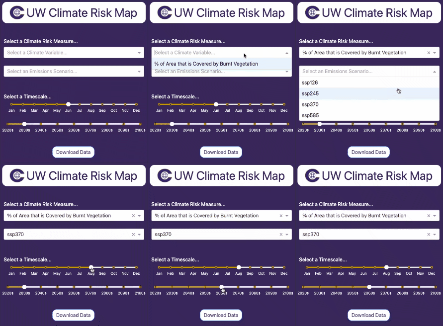
First, we need to select a combination of parameters for the desired climate scenario.
The example on the right illustrates a scenario where the selected measure is "% Area Covered by Burnt Vegetation"—used as a proxy for wildfire risk—under a moderate emissions projection for August in the 2060s.
|
Selecting Infrastructure Overlays
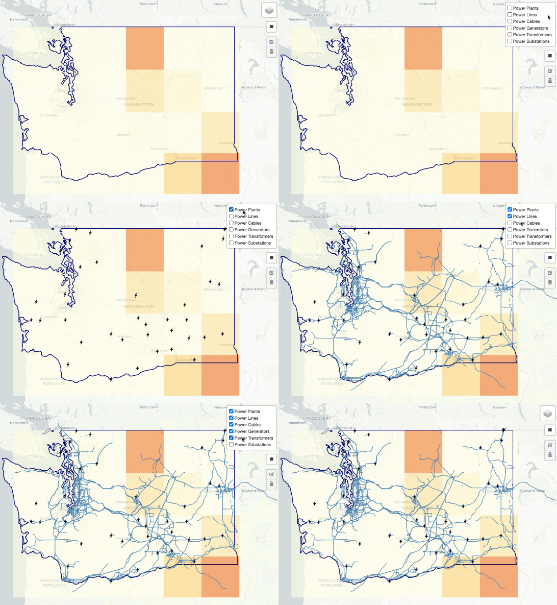
Second, we need to select the specific types of infrastructure we are interested in visualizing.
|
Download Data
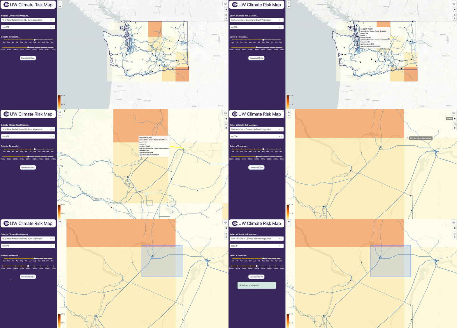
From here, you can explore the map and your particular areas of interest visually to get a sense of asset exposure. You may wish to download the data to do an offline analysis, which can be done easily.
|
Download Data Output
Below is an example of the data structure you might see when you download the CSV file from the Climate Risk Map. For a full list of fields and their descriptions in the download, see Data Dictionary.
| OSM ID | OSM Subtype | County Name | Tags | SSP | Month | Decade | Climate Variable | Climate Exposure |
|---|---|---|---|---|---|---|---|---|
| 41543109 | Line | Douglas County | {'name': 'Grand Coulee-Chief Joseph No 3', 'power': 'line', 'cables': '3', 'voltage': '500000', 'operator': 'Bonneville Power Administration'} | 370 | 8 | 2060 | Burnt Fraction All | 0.945 |
| 41543169 | Line | Douglas County | {'power': 'line'} | 370 | 8 | 2060 | Burnt Fraction All | 1.445 |
| 41543169 | Line | Grant County | {'power': 'line'} | 370 | 8 | 2060 | Burnt Fraction All | 1.445 |
| 40531749 | Line | Douglas County | {'power': 'line'} | 370 | 8 | 2060 | Burnt Fraction All | 2.435 |
| 40531749 | Line | Grant County | {'power': 'line'} | 370 | 8 | 2060 | Burnt Fraction All | 1.689 |
Methodology
This section outlines the methodology behind the Climate Risk Mapping Platform, divided into three key categories: Physical Assets, Climate Science, and Risk Metrics.
Physical Assets
Physical asset data forms a critical component of climate risk assessment. These assets—such as structures, facilities, and infrastructure—represent the elements that, if affected by climate events, could have significant impacts on communities and economies. Our objective is to develop a standardized physical asset data model that can be represented within a database. This model will contain a comprehensive set of asset properties, enabling downstream integration with climate data for the calculation of asset-specific risk metrics.
Currently, we source this data from OpenStreetMap (OSM). The raw data undergoes processing to extract the relevant infrastructure types and prepare them for use in the climate risk model. We cross-reference* the infrastructure data with other external sources to ensure both accuracy and completeness, ultimately creating a reliable dataset for physical asset analysis.
*Infrastructure Validation Pipeline Coming Soon
Climate Science
One major challenge in assessing climate-related financial risk is the disparity between the granularity of climate hazard data and exposure data. Current CMIP6 climate models often provide climate projections at resolutions of 100 km or coarser, whereas exposure data, such as power infrastructure data from OpenStreetMap has a resolution of 250 meters and finer. To have a meaningful risk assessment, climate hazard data must be downscaled to match the resolution of exposure data.
Risk Metrics
Data Dictionary
The Climate Risk Map generally provides data at the asset level, along with associated properties and climate risk measures (exposure, vulnerability, etc...). Below are the initial fields available for download (subject to change).
osm_id: Integer – Unique identifier for each OpenStreetMap (OSM) object. This ID is crucial for referencing and linking OSM features with external datasets or within the OSM database.
osm_type: String – Indicates the category of the OSM feature. For power-related features, this type is typically “power,” representing different aspects of power infrastructure such as power lines or substations.
tags: JSON – A JSON-like field that stores metadata about the OSM feature. Tags may include identifiers, names, and other relevant information (e.g., {'ref': 'GCOU-CHJO-3', 'name': 'Grand Coulee-Chief Joseph No 3'}), providing important context about the feature.
geometry_wkt: String – The geometry of the OSM feature in Well-Known Text (WKT) format, which describes the shape and position of the feature using coordinates. For power lines, this typically defines a line geometry.
longitude: Float – Represents the east-west geographic centroid coordinate of the OSM feature, specifying its position on the Earth's surface.
latitude: Float – Represents the north-south geographic centroid coordinate of the OSM feature, specifying its position on the Earth's surface.
osm_subtype: String – A more specific type of OSM feature within the power category. For example, “line” could represent a power transmission line.
county_name: String – The name of the county where the OSM feature is located, helping to contextualize the feature’s geographic location at a local level.
city_name: String (optional) – The name of the city where the OSM feature is located, if applicable. This field may sometimes be empty if the feature is not within a defined city boundary.
ssp: Integer – Likely refers to the Shared Socioeconomic Pathway (SSP) scenario used in climate models. For example, an SSP value of 370 may refer to the SSP3-7.0 scenario, which models future socio-economic development and its impact on climate change.
month: Integer – Represents the month of the year in the dataset, where 1 stands for January, 2 for February, and so on. This is important for analyzing seasonal climate data.
decade: Integer – Represents the decade of the data (e.g., 2060), helping to differentiate climate data projected for different time periods.
climate_variable: String – Specifies the particular climate-related metric of interest (e.g., “burntFractionAll”). This indicates the environmental factor being assessed, such as temperature, precipitation, or other relevant variables.
climate_exposure: Float – Provides a numeric value indicating the degree of exposure the OSM feature has to the specified climate variable. For example, a value of 1.445 for "burntFractionAll" would represent 1.445%.


